Read the Sky
And Ride More...
by R. Bruce Thomas
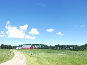
Doesn't that look like a perfect day to go for a ride?
Bright sun, blue Sky, some puffy cumulus clouds, colorful scenery.
What more could you ask for?
But, if that is what you are waiting for to convince you to swing a leg over, you may not get in a lot of riding.
And riding season is short.
It seems that this year we have been getting a lot of rain and storm warnings and forecasts that may discourage planning to get out and ride.
With Weather channels on TV and web sites ready and willing to dish out dire sounding weather, your best bet, in order to make the most of your chances to ride, is to learn to read the sky.
To start, you should be able to recognize the 10 major cloud types.
The high clouds (>20,000 ft) are the Cirrus, Cirrocumulus, and Cirrostratus. These clouds generally don't block sunlight and don't produce precipitation.
The mid-level clouds (6,500 - 20,000 ft) are the Altocumulus, Altostratus, and Nimbostratus. The Nimbostratus is a dark cloud layer responsible for precipitation while the other two are relatively benign.
The low-level clouds (<6,500 ft) are Cumulus, Stratus, and Stratocumulus. A layer of Stratus clouds can produce drizzle and light rain which shouldn't impact your riding.
The tall Cumulonimbus clouds (2,000 - 52,000 ft) should be recognized by everyone as the towering columns that produce thunderstorms and other violent weather.
This site, Cloud Identification, is a good online cloud resource.
Once you can recognize the clouds you can add your knowledge to online information.
The Weather Network provides good coverage of the weather across the country and also has an animated Radar Map (scroll down the page) where you can see how the weather moves over the next four or five hours.
Windy.com is another site you should have bookmarked for riding days as it shows the direction and strength of the wind.
But, nothing beats what you can observe yourself.
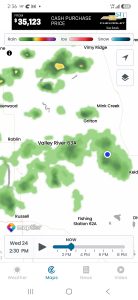 Here's a picture of the radar map I grabbed on a recent ride between Dauphin, MB and Yorkton, SK.
As you can see onscreen, I (blue dot) should be experiencing a wet ride.
This next picture is what I actually saw on the road.
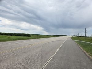 The road is bare and dry and there is no visible precipitation below the cloud layer in my vicinity.
This highlights something else to remember. Weather radar highlights atmospheric moisture but doesn't always indicate whether precipitation is coming down to the ground. This is why you may find observational differences and why you shouldn't just base your riding decisions on media content.
If you want to know the weather, step outside.
And now that you know the cloud types, and what to expect from each of them, you'll be able to make better informed decisions about when to ride and in which direction.
Ride responsibly, and often.